
Relesing data to inform travel choices is nothing new. It has been part of the transport sector’s offer from George Bradshaw’s mid-19th Century aggregation of timetable data from some 150 rail companies to the Traveline initiative to provide comprehensive journey information on the deregulated bus market at the turn of this century.
What is now referred to as the open data agenda presents opportunities to provide better information to the public to inform their travel choices but also challenges the transport profession. For instance, there is a concern in the sector at the uses to which data is put and local authorities have questioned whether there is a business case for releasing data with commercial value for free.
The profession has acknowledged that, even if the data they hold is not released, data collected by others will be provided to road users and passengers. The then County Surveyors’ Society and Chartered Institution of Highways and Transportation highlighted to ministers over five years ago the scope for sat navs to undermine traffic managers’ strategies by encouraging motorists to follow different routes from those advised by fixed or variable signs.
The amount of information collected without recourse to the public sector has grown since then. There are smart phone apps that allow the ‘crowd-sourcing’ of information on congestion conditions on the road network, information that is both inputted by motorists and automatically generated by the apps tracking the GPS location of the phones.
The public sector owners of data are now releasing it as open data, which means that there are no licensing restrictions on its re-use. For example, the Highways Agency entered into an agreement with sat nav firm TomTom last summer to supply the live traffic information from automatic traffic counters to motorists through their sat navs. The HA also agreed to supply this data to Googlemaps, supplementing crowd-sourced data.
The HA is now releasing data on planned and unplanned disruption for app developers to re-use as open data, in line with a commitment made by the Prime Minister.
A Highways Agency spokesman told LTT that re-publishing existing data services as open data services was “relatively painless”. The HA’s National Traffic Information Service makes available the data used for traffic management and communicating to road users via variable message signs. This data, which provides updates on current road works, planned and unplanned events and journey time data every ten minutes, and data on future works and events on the road network every six hours, feeds the HA’s own smartphone live traffic app that provides a simple text-based summary of incidents and street works on each motorway or A road.
No additional budget has been provided for the open data agenda by the Agency, he adds. “So far there has been no significant increase in support costs beyond the initial effort to publish via open data. The principle of open data is supporting the re-use of existing data and all data released to date has been transferred into machine-readable format without any additional spend.” A machine-readable format is what is required for developers to use data made available in order to create new apps for the public.
Potential developers must enter a username and a password and agree to an ‘acceptable use’ policy allowing the HA to monitor use. The HA has not worked with developers to date, but this is “an aspiration as we move forward,” the spokesman says. The Agency has established a transparency governance group and a supporting open data group that “will oversee and co-ordinate future data releases to ensure that the data is of an appropriate quality and in an appropriate format to ensure we support the re-use agenda”.
Discuss this at LTT's Open Data, Cities & Transport Event on the 27 Jue 2012
Information on travel conditions when motorists turn off the strategic road network is not yet freely available. The Prime Minister committed the DfT and local traffic authorities to make available the real-time data from urban traffic management systems and data held on road or lane closures in streetworks registers by the end of 2012. The HA will encourage developers to dovetail that with their own information to provide end-to-end journey traffic information.
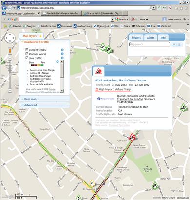
ELGIN, the private company that aggregates data on streetworks from over 90 local highway authorities, provides the biggest dataset on traffic conditions. The company both feeds this to its roadworks.org website and also redistributes the information under the Open Government Licence. From this month, the company is to provide a live data feed to real-time traffic data company INRIX.
INRIX will blend the data with the data it already collects from 3,000 cameras and 200,000 vehicles on the UK road network that it continually tracks to determine where the traffic is slow. Shane O’Neill, chairman of ELGIN, says: “Open data campaigners often refer to public sector organisations who do not release their data as ‘data huggers’. But there is a very proper concern in the public sector as to the uses to which some Government data is put – at certain times the information may not exactly reflect what is happening on the roads.”
The issue with the ELGIN national dataset is that there could be a slight time lag between when the works on the highway network are carried out and when the work notice is placed on the register. Combining the data with the INRIX data makes the information “more reliable for motorists and the freight industry,” O’Neill adds.
This is the first in a series of major partnerships planned by ELGIN in which O’Neill says the company will share the public data with the private sector in a responsible way. “By responsible, we mean that it satisfies the local traffic authority desire for accuracy. The data is provided for re-use using an Application Programme Interface (API) that reduces any error by manual intervention and ensures that data is provided in as timely a fashion as is possible,” he says. APIs are used to share data between different applications, which is how a Youtube video can be played on Facebook.
Data on traffic conditions could potentially benefit all road users. CycleStreets is providing a UK-wide cycle journey planner system, currently in the testing stage, that allows the planning of journeys by bike and highlights busy sections of road and factors in the delay to journey times caused by hills and traffic signals.
CycleStreets combines a number of datasets including, crucially for cycling journeys, data from the Ordnance Survey on the gradients of streets. CycleStreets wants to integrate data on the times and locations of road works, which can disrupt cycling journeys. Apps such as this are made possible by maps available as open data such as OpenStreetMap or the Ordnance Survey Open Data mapping layer. These are simple maps on a scale of 1:50,000. Local authorities, under the Public Sector Mapping Agreement with the OS, can display more detailed information (see box, below).
Information on the larger-scale OS maps from the National Street Gazetteer necessary for journey planning by road such as height and width restrictions, direction restrictions and bus and other priority lanes is not available as open data. The DfT’s transparency board is discussing whether or not this can be released with an Open Data Licence.
The custodian of the National Street Gazetteer is GeoPlace, a joint venture between the Local Government Association and the OS that collates information on roads and addresses. Among this limited liability partnership’s tasks is to continually update the data on roads classifications such as ‘A’ and ‘B’ roads, which local authorities now have the power to change without Whitehall approval.
Jonathan Raper, managing director of transport data aggregating company Placr, believes that the current situation “is a significant obstacle to the sector exploiting traffic data”. “Why is information on the location of the nation’s one-way streets behind a paywall?”
One consequence was that Transport for London had to re-engineer data on real-time traffic disruptions it is due to release this month so that the alerts for road users correspond to street names rather than to OS topographical identifiers.
What the DfT’s transparency board sees as one of the biggest open data success stories is the release of information on public transport routes and access points in the National Public Transport Gazetteer.
This means that the location of bus stops and services is available across the UK through Googlemaps and OpenStreetMap, which the DfT transparency board considers will increase public transport use and is a good model for data release. The information is made available by Traveline, the partnership between local authorities and transport operators that first trialled the provision of data on door-to-door journey planning through a website a decade ago. The partnership is now making available information on real-time bus running and sees open data as improving the attractiveness of services – it has, if anything, become too successful.
Discuss this at LTT's Open Data, Cities & Transport Event on the 27 Jue 2012
TransportXtra is part of Landor LINKS
![]()
© 2026 TransportXtra | Landor LINKS Ltd | All Rights Reserved
Subscriptions, Magazines & Online Access Enquires
[Frequently Asked Questions]
Email: subs.ltt@landor.co.uk | Tel: +44 (0) 20 7091 7959
Shop & Accounts Enquires
Email: accounts@landor.co.uk | Tel: +44 (0) 20 7091 7855
Advertising Sales & Recruitment Enquires
Email: daniel@landor.co.uk | Tel: +44 (0) 20 7091 7861
Events & Conference Enquires
Email: conferences@landor.co.uk | Tel: +44 (0) 20 7091 7865
Press Releases & Editorial Enquires
Email: info@transportxtra.com | Tel: +44 (0) 20 7091 7875
Privacy Policy | Terms and Conditions | Advertise
Web design london by Brainiac Media 2020