
The Luton-Dunstable-Houghton Regis conurbation is home to 257,000 people (205,200 in Luton) living in just over 97,000 households. About 20% of households in Dunstable and Houghton Regis do not own a car, rising to 27% in Luton. The conurbation provides about 102,000 jobs, of which 80,100 are in Luton.
About 60% of journeys to work are less than 10Km. The dominance of car travel and shortness of most journeys to work, combined with the limited “bridging points” over the M1 motorway and railway lines, leads to peak traffic congestion particularly on the east-west roads connecting the three towns. This has a severe impact on journey time reliability particularly for bus services.
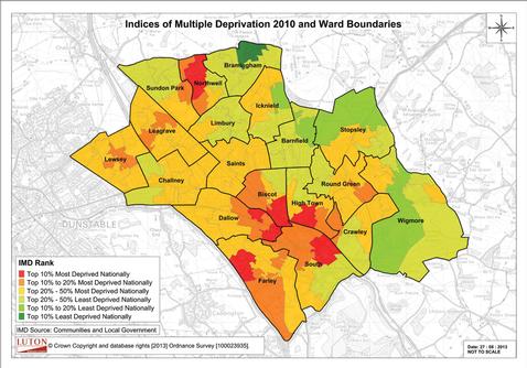
Since the mid 1990’s the conurbation’s economy has been vulnerable largely as a result of manufacturing job losses. There are ten wards in the conurbation that have unemployment rates greater than the national average, contributing to higher levels of deprivation. The focus of local economic policies to reduce this unemployment is on training and re-skilling the local workforce.
The airport also plays an important transport and economic role, with around 8000 people employed on the airport campus. Passenger throughput has increased from 3.2 million passengers per annum (mppa) in 1997 to around 10mppa in 2011. A planning application submitted in late 2012, which is currently being assessed by the Council, would increase passenger throughput to 18 mppa.
The genesis of the Busway
At the start of the scheme development process, five objectives were defined, consistent with both National and Local policy considerations. These were subsequently used to develop an outline system specification for the Busway and also form the basis of the Evaluation Plan for monitoring its success:
Objective 1 – Facilitate more reliable bus travel, as an attractive alternative to car use The guided Busway crosses main roads on bridges and includes intermediate access points, allowing buses to bypass congested routes in the Luton-Dunstable corridor and facilitating bus priority measures around Dunstable and Luton town centres.
Objective 2 – Improve accessibility The core Busway route enables buses to connect residential areas in Dunstable, Houghton Regis and the west of Luton with the three town centres and the airport.
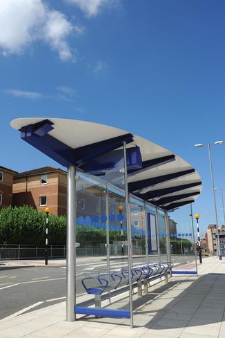
Objective 3 – Improve personal safety The scheme incorporates improved passenger facilities both on the Busway and about 200 on street stops, including real-time passenger information, CCTV, improved shelters and level boarding.
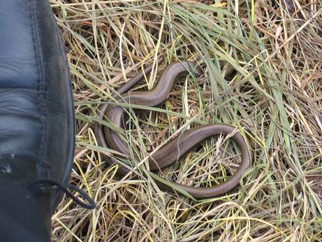
Objective 4 – Environmentally friendly Not only are buses a more environmentally friendly form of transport, but the environmental credentials in developing the scheme are also important as the entire disused railway corridor was classified as a County Wildlife Site.
Objective 5 – Supporting local planning and regeneration policies The Busway passes close to a number of development sites identified in the Local Plans for the area. It is also capable of being extended to serve potential development sites to the north of the conurbation included in the emerging Central Bedfordshire Development Plan.
An access track for use by emergency and maintenance vehicles runs alongside the Busway west of the M1, as this section cannot be accessed from local roads. This access track can also be used by pedestrians and cyclists, contributing to the local walking and cycling networks in Dunstable and Houghton Regis.
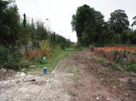
The cycleway also continues east of the M1into Luton. The Luton-Dunstable railway closed to passenger traffic in 1963, but continued to serve the Blue Circle cement works in Dunstable until the late 1980s. A review of the Transport Strategy for the conurbation undertaken by MVA Consultancy for Bedfordshire County Council started in 1990; its key elements included improvements to public transport services and re-use of the disused railway line.
The development of the Busway scheme followed the DfT’s four stage process of assessing and consulting on options, followed by development of a business case for the preferred option, carrying out the statutory procedures for the scheme, and procuring the contractor to implement the scheme. Throughout the process the project management arrangements have involved regular meetings between the project team and the consultants, together with reporting to Members at key stages in the decision making process. Following the outcome of the Statutory Procedures, and to reflect Best Practice, in early 2007 the governance arrangements changed from the “scheme development and approvals” phase to a “construction and delivery” phase to include a Project Board including the Directors of the two Councils responsible for Highways and Finance.
Assessing the options
In recognition of the importance of the corridor previously served by the railway, a number of studies were undertaken to examine the public transport options for meeting the evolving transport needs and objectives of the conurbation. These included proposals to re-open the Luton Dunstable railway in Network South East’s Plan published in May 1989 and two feasibility studies of heavy rail options between Luton and Dunstable commissioned by Dunstable Town Council in 1991 and 1993. A more detailed technical evaluation of public transport options for the corridor was carried out by MVA in 1993/94. In addition to the Busway, other options considered included:
The environmental impacts of all these options were similar in that they all used the disused railway corridor between Luton and Dunstable, which was designated as a County Wildlife Site. Given that parts of the scheme run past houses, it was also necessary to take into account the impacts of different options on air quality, noise, and visual intrusion; the last two of these areas are where heavy rail options performed less well. However, the fundamental difference was that the Busway provided greater flexibility as buses could join and leave the track at access points.
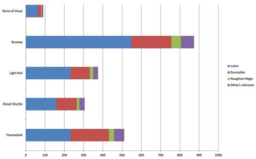
The outputs from this study formed the basis of public consultation undertaken by Bedfordshire in 1994/95. Public exhibitions were held in November 1993 at various venues close to the proposed Busway corridor. A total of 2137 questionnaires were returned, and people’s preferences for the various options are summarised in the consultation results. Despite the greater preference for the Busway, in deciding which option to progress, Members of the County Council requested further consideration of the heavy rail options before deciding to support the Busway. Consequently it was only in 1996 that the County Council agreed the Busway as the preferred option.
Getting under way
When Luton became a Unitary Authority in April 1997, they took over the lead role in the project. After a review of previous work, consultants Mott MacDonald and CES (subsequently Faber Maunsell) were respectively appointed in early 2000 to undertake initial engineering and environmental design of the Busway scheme.
By autumn 2000, sufficient work had been carried out on these aspects for Luton and Bedfordshire Councils to consult local people about the details of the Busway. Whilst the consultation leaflet and exhibitions focussed on the Busway, they did include some information about the diesel shuttle alternative. In summer 2001, the Councils paid for an advert in the local press that summarised the outcome of the consultation.
Some of the conclusions, in particular five comparators between the Busway and heavy rail alternatives, were challenged by a local resident complaining to the Advertising Standards Agency, resulting in a 6-9 month period over which the Council had to defend its case. A Major Scheme Business Case (MSBC) was prepared to support a funding application to the DfT, which was submitted in September 2000.
An independent assessment of the Business Case carried out by Atkins concluded that further work was required, particularly regarding the demand and revenue forecast modelling. The MSBC was updated and resubmitted to the DfT in September 2001. By that December, the Councils believed that initial funding approval could be forthcoming in the following spring and therefore in early 2002, the pre-order consultation started.
Letters were sent to all residents, landowners and owners/occupants of commercial premises that were likely to be most affected by the Busway proposals which included plans and cross sections showing the design and proposed landscaping treatment in the vicinity of their premises. Ten groups of residents and thirty owners of commercial premises engaged in discussions with the project team. As a result some amendments were made to the scheme design to address the concerns raised, including reviewing the Busway and access track alignment in the areas around Dog Kennel Down and Blows Down Site of Special Scientific Interest, lowering the Busway alongside the residential park homes site at Caddington Park, and reducing lateral clearances alongside Luton Town Football Club.
However the expected funding announcement was significantly delayed as Government was undertaking a review of its “Green Book” appraisal methodology. A revised Business Case for the scheme was submitted to the DfT in September 2003, and on 18th December 2003 they announced “Programme Entry” status.
On the same date, the Councils applied to the DfT for permission under the Transport and Works Act (TWA) to construct and operate the Busway between Luton, Dunstable and Houghton Regis. The TWA application comprised the Order and a list of other consents required, an Environmental Statement, Order plans and Book of Reference, and an Application for Deemed Planning Permission. The TWA Rules require both Councils to make resolutions before submitting the TWA Order together with a confirmatory resolution shortly after. Bedfordshire County Council decided to withdraw support on 12th February 2004. Luton was due to take its confirmatory resolution a week later but delayed taking this decision until they had sought legal advice from the DfT.
In April Luton confirmed to progress the scheme as a sole promoter, and an amendment to the Order was published later that month. In June 2004, agreement was reached with Bedfordshire that they would continue as a full supporting partner. A second objection period commenced on 29th April 2004 and ended on 11th June 2004. In total 383 objections were received over the two objection periods. On 13th July 2004 the Secretary of State announced his intention to hold an Inquiry into the application for the proposed TWA Order.
The Public Inquiry commenced on 15th February 2005 and closed on 1st August 2005. During that time there was a 3 month recess between the end of March and early June, with shorter recess periods up to the close of the Inquiry. The main issues raised by objectors at this Inquiry were consideration of heavy and light rail options, together with issues raised by adjacent commercial premises affected by the Busway scheme.
A second Inquiry into draft Section 19 certificates for replacement open space was held on 1st and 2nd May 2006. On 2nd November 2006 the Secretaries of State published their decision letters following the two Public Inquiries. The TWA Order was subsequently made on 13th December 2006. During 2006/2007 a financial review of the Busway scheme was undertaken jointly by Grant Thornton supported by Jacobs. The results of that review were presented to Luton’s Scrutiny Committee in April 2007. The key findings of this review were that the scheme could be delivered within the budget; risks were ‘manageable’ but needed updating; a Design and Build contract was most appropriate for implementing the scheme; Busway services should be delivered through a Quality Partnership agreement, and further work was required on maintenance and other costs.
The study also proposed a review of the Busway route in the context of the development proposals for the former Vauxhall Motor Works site on Kimpton Road and on the south-east side of the town centre. During the rest of that year further work was undertaken in developing these various aspects, in particular taking further advice on the most appropriate ways of procuring the Design and Build contract for the Busway together with bus service operations. The design was also amended to accommodate the above development proposals, replacing the bridges at Church Street and Kimpton Road with at-grade junctions. This work informed the completion of the MSBC for the Conditional Approval, which was submitted to the DfT on 29th February 2008.
Securing funding
On 3rd September the DfT wrote to Luton awarding Conditional Approval, and setting out the Conditions under which Full Approval would be awarded, which included confirmation that the scheme remains unaltered; Confirmation of the total scheme costs and the DfT/third party contributions; further details of the Project Governance arrangements; details of the Tendering exercise and any resulting changes; and Confirmation that operators are committed to provision of services together with details of any contractual agreements that are either in place or being developed
An OJEU notice was published in February 2008, and that May the Project Board approved a shortlist of 3 contractors to be taken forward to the full tender stage. Early the following Spring, draft instructions for tendering, Site Information (including topographical and geotechnical surveys) and risk information was issued for comments to the shortlisted contractors, which helped inform the final tender documentation that was issued in May 2009. There were regular meetings with tenderers during the tender period including risk workshops to aid the development of an agreed tender/contract risk register.
Tenders were returned on 23rd September and the assessment process was undertaken over the following weeks, with two separate teams initially assessing the quality and price submissions. Workshops were held with each tenderer in mid October to seek clarification on various matters relating to their submissions. Following this, the quality and financial panels met to confirm BAM Nuttall (BAMN) as the preferred bidder to be recommended to the Project Board in November, and subsequently confirmed by the Executive Committees of Luton and Central Bedfordshire Council, the successor to Bedfordshire County Council from 1st April 2009.
Luton submitted the MSBC for Full Approval to the DfT on 15th December 2009, and on 10th March DfT wrote to the Council confirming funding. BAMN’s Tender identified a Joint Venture (JV) of Arup and Parsons Brinkerhoff to undertake the design, together with specific sub-contractors to undertake particular elements of the Works such as bridge demolition, retaining wall construction, earthworks and landscaping. BAMN were appointed using a target price contract with activity schedules under the NEC3; the Tender target cost was £51,613,363.
Under this form of contract, the target price can be adjusted up or down as Compensation Events resulting from changes to the Works Information that are notified by either the client or contractor as Early Warning Notices. The BAMN contract was for the design and construction of the Busway and associated access track (including bridges/retaining walls, Busway stops/Luton station interchange, access points, and environmental mitigation). Because of the delays in awarding funding, the Council asked BAMN to clear the vegetation along the Busway corridor as a separate advance Contract. There were also separate contracts for other on-street works (with the Councils’ term maintenance Contractors) communications for Real Time Passenger Information (RTPI) displays and CCTV (through a sub-regional contract with Vix). The two most important aspects of managing the contract are control of costs and the works programme. The Councils contract Project Manager (PM) is backed up by a team of engineers and quantity surveyors who advise the PM on the acceptability of all aspects of the design and construction, assisting him in certifying BAMN’s monthly payment submissions. The client staff resources required to undertake this work should therefore not be underestimated. Atkins were appointed to assist the Council in this role.
Ecological improvements
Given the entire disused railway corridor was classified as a County Wildlife Site, extensive ecological surveys were undertaken. The Councils worked with the Wildlife Trust and local groups to develop a biodiversity action plan for the Busway corridor. Four areas of land were identified for improvement to mitigate the impacts of constructing the Busway These sites were either in public ownership but not currently actively managed or are in private ownership and not managed at all for biodiversity interest. The Councils have signed up to a 60 year agreement with the Wildlife Trust to manage these sites. Botanical, bird and invertebrate surveys have been carried out on all these sites during the last 18 months by the Wildlife Trust to provide us with baseline information as to the conditions of the habitats. Various flora and fauna were translocated before construction started, including :
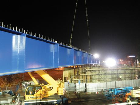
The nuts and bolts
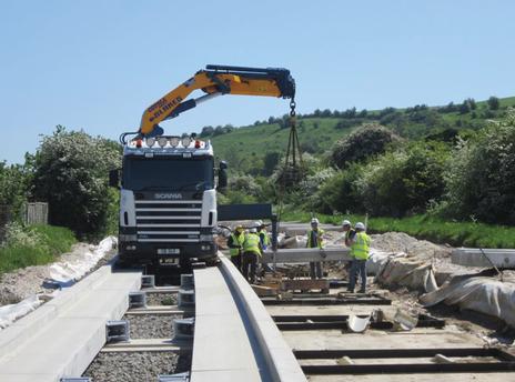
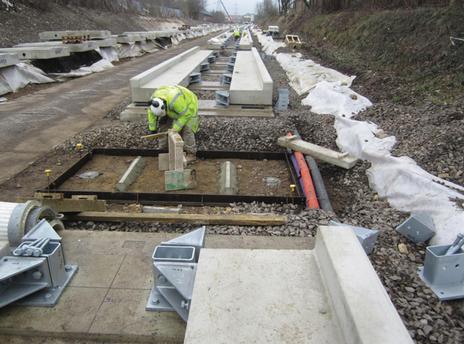
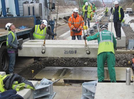
Each guideway beam is 6 metres long, supported on and bolted to a pad at each end together with a central pad; a straight beam and four radii were planned to be cast. A key element in the design was the ‘segmentation’ of the guideway alignment, which involves determining which type of beam should be positioned where along the whole length. The Works Information section of the contract specified design should be carried out in accordance with the Guided Busway Design Handbook and the Design Manual for Roads and Bridges, including consideration of the impact on ride quality as the bus moves from one beam to the next. As part of the Value Engineering process, the requirement for meeting highway loadings was challenged. Load testing, backed up by structural calculations, was undertaken to determine if the central pads and brackets could be removed. This concluded that, with the exception of those parts of the guideway where buses brake on approaches to Busway stops, junctions, and “burst throughs”, guideway construction with two sets of pads and brackets would not have a detrimental impact on ride quality or structural stability.
The Launch of the busway
The Busway will be formally opened on 24th September by Norman Baker MP, Minister for Transport. Full bus services will start the following day and will comprise the four routes.
Implementation
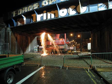
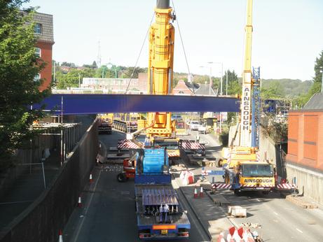
Work on demolishing and rebuilding bridges has generally progressed well. However earthworks were affected by unforeseen obstructions, including buried sleepers and sections of retaining wall, together with contamination east of Chaul End Lane and two 21 metre deep wells near Station Road in Dunstable. These problems were not surprising given the Busway occupies the disused rail corridor, together with the fact that, as identified in the Environmental Statement, the old Laporte chemical works (which closed in the early 1980s) was located between Chaul End Lane and Kingsway and that much of the water supply is obtained from the underlying aquifer.
Various problems with utilities were experienced in constructing junctions and access points. These included uncharted services and utilities companies altering the scope of works at a late stage, needing changes to the Busway design and construction, resulting in some delays.
The first beam was laid in December 2011, and the last one in May 2013.
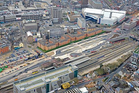
The on-highway works have been delivered through the term contracts of the two Councils. Council engineers undertook a review of the transition kerb design at on-street stops to enable docking and level boarding by vehicles fitted with guidewheels. All stops have new footway works and coloured surfaces, together with bus shelters for many of the stops. In addition to constructing the 180 on-street stops along the routes of the planned bus services, the Council’s term contractors also designed and built further on-street measures; in particular these included easing radii at junctions in the Downside area of Dunstable together with the ‘shared surface’ in Court Drive, also in Dunstable.
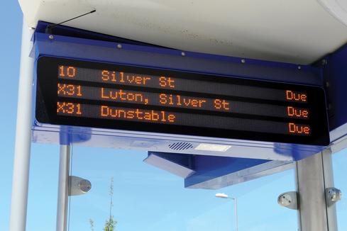
The Councils are members of a sub-regional consortium for the provision of RTPI; Vix currently provide this service. The project team engaged with Vix in order to determine the optimal solution to provide RTPI and communications to the main bus stops along the Busway, key interchanges, other on-street bus stops and on-bus displays. RTPI displays have been included at all on-street stops, either as a 3 line LCD display mounted in the shelter (Shannon) or pole mounted (BAN). In addition all stops on the Busway and a few key on-street stops include the ability to display advertising and community information. All of these RTPI displays support React 3 audible announcements activated by use of a key fob, as an aid for passengers that are visually impaired.
Three options were considered for the digital communications needed to support these enhanced stop facilities including help points and CCTV; Wireless mesh serving both the Busway and the on-street stops; Fibre optic cable along the Busway with GPRS communications (SIM card technology) to the on-street stops, and Fibre optic cable with Last Mile Microwave Wireless to the on-street stops. The second of these options was agreed by the Project Board as the preferred solution as it was a lot cheaper to install despite the fact there were some associated ongoing costs.
Bus operations
Early in the scheme development, three key criteria were set for service operations on the Busway including a minimum frequency of 4 buses per hour in each direction; service operations between 06:00 and 23:00; and a minimum quality standard for buses.
Several ways of procuring these levels and standards of service were considered, including licensing operators to use the guided Busway, commercial operation by bus companies through a Quality Partnership Scheme, contracts between the operator and the Councils, and Quality Contracts. The Quality Partnership was the preferred option.
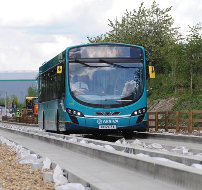
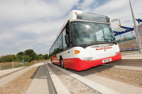
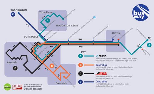
In May 2009 the Councils published an Expressions of Interest advert to operate bus services on all or part of the Busway. Four operators responded, all of whom operate local bus services. Following further dialogue with each Operator, they were asked to sign a Development Agreement with the Councils and invited to attend the monthly Bus Operations sub-group meetings and contribute to discussions about matters where their experience was relevant, in particular with BAMN or the Council’s term contractor about the design and specification of stops and associated infrastructure, or about timetables and multi-operator ticketing. Arriva and Centrebus signed this agreement in Autumn 2009, and on the strength of such commitments, the Councils entered into contracts for the construction of the Busway and associated infrastructure. In late 2012 Grant Palmer also showed an interest in running services. Figure 9 shows the services using the Busway together with the on-street stops.
In early 2011, the operators agreed to introduce a multi-operator ticket, Hip Hop. This has been available since July 2011 as a paper ticket, with revenue “sitting where it lies”. Since then the Councils have worked together the operators to develop the specification for Busway vehicles, implement Smartcard-enabled ticket machines on buses, and develop branding/
marketing principles. Work is also underway to migrate the Hip Hop ticket to a Smartcard ticket in the next few years.
A Quality Partnership agreement has been developed and the Councils and the three operators have signed up to this, with service frequencies on the core Busway route between Dunstable and Luton specified in a Qualifying Agreement.
Various test runs along sections of the Busway have taken place since Spring 2012. Once the whole Busway was substantially completed, journey time trials took place in mid-June 2013, to provide each operator with information to prepare their bus timetables for submission to the Traffic Commissioners. The following month, tests of the turning moves at each access point took place using single deck, double deck and articulated buses; this was a requirement of the construction contract.
A “bus operations and safety manual” has been prepared, that summarises the features of the scheme and includes advice for driving technique when entering and leaving the Busway at access points, as well as driving along it. The original intention was that this manual would also include details of emergency procedures and alternative routes to be followed in the event of an incident on particular sections of the Busway. Given that each of the three bus operators already have “established” emergency procedures, and the routes to be followed in the event of closure of sections of the Busway will vary for different operators, then each operator has been provided with the ‘framework’ of this manual to add to as required. In terms of emergency procedures, the only aspect that will be common to all three is the removal of a ‘broken down’ bus, with all three operators agreeing to use “Bedfordshire Recovery”.
The Launch of the busway
The Busway will be formally opened on 24th September by Norman Baker MP, Minister for Transport. Full bus services will start the following day and will comprise the four routes.
TransportXtra is part of Landor LINKS
![]()
© 2026 TransportXtra | Landor LINKS Ltd | All Rights Reserved
Subscriptions, Magazines & Online Access Enquires
[Frequently Asked Questions]
Email: subs.ltt@landor.co.uk | Tel: +44 (0) 20 7091 7959
Shop & Accounts Enquires
Email: accounts@landor.co.uk | Tel: +44 (0) 20 7091 7855
Advertising Sales & Recruitment Enquires
Email: daniel@landor.co.uk | Tel: +44 (0) 20 7091 7861
Events & Conference Enquires
Email: conferences@landor.co.uk | Tel: +44 (0) 20 7091 7865
Press Releases & Editorial Enquires
Email: info@transportxtra.com | Tel: +44 (0) 20 7091 7875
Privacy Policy | Terms and Conditions | Advertise
Web design london by Brainiac Media 2020