A dashboard that displays school run traffic across primary schools in London has been developed to illustrate current travel behaviour. The data model, developed by campaign group Solve the School Run, is designed to help parents better understand school run traffic, and work out which school trips are most likely to be made sustainably and which are likely to be driven.
The analysis will help campaign groups and councillors quantify the numbers of pupils making these journeys at a local school, ward or borough level, and strengthen case for safer streets, says Solve the School Run, set up by Claire McDonald and Nicola Pastore.
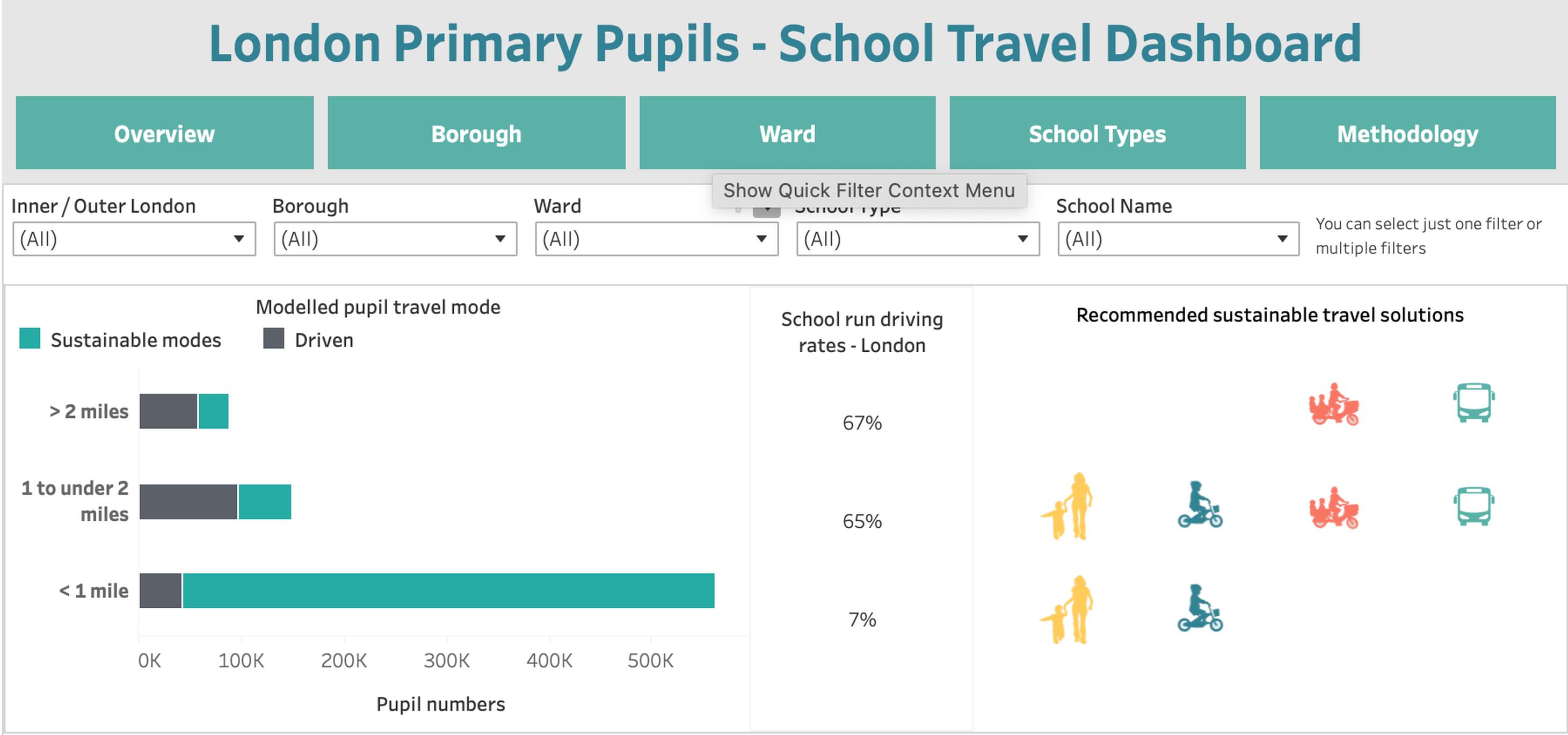
The dashboard is based on the DfT’s National Travel Survey (NTS) analysis. This indicates the average driving rate for a London primary pupil travelling under one mile to school is 7%, which increases to 65% for distances of between one and two miles.
“The distance pupils have to travel to school is a huge determinant of how they travel,” says Solve the School Run. “The larger the catchment area of a school, the higher the levels of driving.”
Solve the School Run is calling for better publicly funded infrastructure for journeys over a mile. This, it says, could involve: staffed walking or cycling groups; better cargo bike infrastructure, such as subsidies and secure cargo bike parking; or flexible mini-bus services for schools with larger catchment areas.
For many London wards and boroughs, an estimated 70% of primary pupils are walking or cycling short journeys of under one mile to their local primary schools, says Solve the School Run. “That is 560,000 primary pupils who often make these journeys alongside very high levels of traffic, high pollution levels and limited safe route infrastructure like cycle lanes or zebra crossings.”
The data model includes an estimate of pupil travel distances and modelled driving rates for school types with longer school runs, such as independent schools. This school type selects pupils from beyond their local area, which means primary pupils may have longer school runs, and associated higher levels of driving.
Unlike state schools, independent schools do not have to disclose their pupil distance information, so they have typically been left out of analysis of this type, says Solve the School Run. “However, making up 10% of total primary pupil numbers in London, up to 45% in some boroughs and wards, they are an important part of the issue, which is why an estimate has been included.”
TransportXtra is part of Landor LINKS
![]()
© 2026 TransportXtra | Landor LINKS Ltd | All Rights Reserved
Subscriptions, Magazines & Online Access Enquires
[Frequently Asked Questions]
Email: subs.ltt@landor.co.uk | Tel: +44 (0) 20 7091 7959
Shop & Accounts Enquires
Email: accounts@landor.co.uk | Tel: +44 (0) 20 7091 7855
Advertising Sales & Recruitment Enquires
Email: daniel@landor.co.uk | Tel: +44 (0) 20 7091 7861
Events & Conference Enquires
Email: conferences@landor.co.uk | Tel: +44 (0) 20 7091 7865
Press Releases & Editorial Enquires
Email: info@transportxtra.com | Tel: +44 (0) 20 7091 7875
Privacy Policy | Terms and Conditions | Advertise
Web design london by Brainiac Media 2020